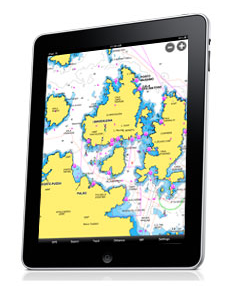
Enjoy the clearest and most detail marine and lake charts on your iPad*! Apps now optimized in HD – with sensational hi-resolution graphics for the ultimate user experience! Imagine planning your day on the water or showing your friends the tracks of your last cruise on the iPad’s dynamic multi-touch glossy display, comfortably sitting in your living room… or anytime, anywhere!
Why buy Navionics HD? Our iPad app has everything you need:
Award-winning Marine charts worldwide and Lake maps (only for US and Canada)
• Satellite imagery overlay
• Tides & Currents, Moon phase, Sun/Moon rise/set
• Tracks, Routes and Markers on Facebook or via Email and view them on Google Earth
• Route planning
• Waypoints & Markers
• The largest database of marine POIs available
• In-app Facebook
*iPad Wi-Fi only locates your GPS position if Wi-Fi connected, iPad GPS+3G works as an iPhone
Ideal for boaters, fishermen and water sport enthusiasts of all kinds. You can plan your on-the-water adventures anytime and anywhere… check tides, set your routes and markers, and search for marinas. While on the water track your navigation and create a virtual travelogue of your entire trip that you can share with your friends and family via email, Facebook and the Navionics community.
Choose from several Navionics HD Apps currently, with more coming every day. Twenty four marine apps to choose from worldwide. Five lake apps covering the US and Canada with hundreds of high-definition (1’ contour) lakes and thousands of the most popular lake maps.

