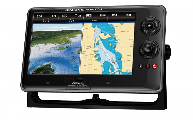
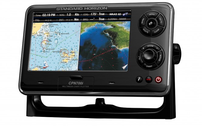
Standard Horizon has just introduced the CPN700i and CPN1010i chart plotters, a new generation of touchscreen 7-inch and 10-inch full colour models with internal antennas, featuring a typical Standard Horizon innovation. They will be on display at METS 2011, stand 04.541.
Perhaps the most versatile advance is that both models are the first ever to have built in Wi-Fi, allowing the navigator to access the internet and email when moored in a Wi-Fi hotspot. Movies and music can also be downloaded and played thanks to included Windows Media Player software and a USB port for a memory stick, whilst the plotters’ built-in front speakers are expandable via an audio port on the back to add a separate amplifier.
When navigating, the new CPN models are unsurpassed, with the option to use the very latest C-Map 4D charts from Jeppesen. This system not only provides the very latest in accurate electronic charting, but also allows for the overlaying of satellite photographs and vector charts, so the navigator can source all the detailed information available on an area. The 4D element refers to the fourth dimension of time, ensuring that the charting software receives the latest notices to mariners and other updates via the web. With C-Map 4D, there are two chart products on one chart, allowing the user to choose either Max or 4D content, and then unlock’ data or add new charts as they become available.
With all this navigational power available, Standard Horizon has made the new CPN700i and CPN1010i as intuitive to use as possible, with some highly desirable operating features. There is a dual screen function, for example, which allows the plotter to be used with two separate plotter displays simultaneously – one zoomed in for close quarters navigation whilst the second offers a ‘bigger picture’ overview.
There are also three ways to manipulate the controls, either by touch screen, or by the ShuttlePoint knob to move the cursor, or via menus using the Rotary Knob with its push-to-enter facility. Hard keys allow the chart image to be tilted up or down, or even rotated through 360 degrees. A dedicated Chart key can be used instead of scrolling through menus to quickly show vector, raster or satellite information, with a Mark key to create a single waypoint.
Both the CPN700i and the CPN1010i can be expanded by linking them to a compatible VHF DSC fixed radio. This allows private polling to be made via a DSC directory, with the position of a polled vessel, or one sending a distress alert, to be shown on screen. The plotters can also be linked to the Standard Horizon GX2100E VHF DSC transceiver which also has a built in AIS receiver, for overlaying AIS targets on the chart screen. This will identify nearby vessels and show their course, speed and approach details on the screen. There is also the option to add the FF525 fish finder for which Standard Horizon offer a range of transducers.
Using a tough sunlight viewable screen (1024 x 600 – CPN1010i and 800 x 480 – CPN700i), and a 50 Channel WAAS GPS receiver, both plotters offer the very latest in state-of-the-art electronics, with the ability to update your emails, and music collection, whenever you are in range of Wi-Fi. There are even dual video inputs to connect the CPN1010i to NTSC or PAL video cameras or a standard DVD player. The 10 inch colour screen can be used to show an entire image, or picture in picture, ideal for remote engine room monitoring.
So confident is Standard Horizon about the build quality of each set, they are offering a 3-year hassle-free waterproofing guarantee. Prices start at: £999.95 inc VAT for the CPN700i and £1574.95 inc VAT for the CPN1010i.
Technical Features:
– XVGA sunlight viewable bonded touch screen display
– Built-in Wi-Fi
– Bundled Multimedia Internet Explorer 6.0 and Windows Media Player software
– USB connection to watch movies, view pictures or listen to music
– Dual station networking capability
– Optional C-Map 4D cartography
– Unique bonded touch display with ‘zoom and swipe’ capability
– Internal 50 channel WAAS GPS antenna with external aerial connection
– Dual chart window with independent zoom levels
– AIS, Fish Finder and NTSC or PAL video inputs
– 1 VGA video output
– 3000 marks/50 routes/20 tracks with 10,000 waypoints
– Supplied with both mounting bracket and flush mounting kit
– 3-year waterproof warranty

